


- You are here:
-
Sights by Regions

- Kirovohrad region
Kirovohrad region



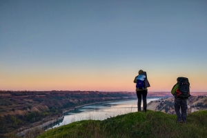


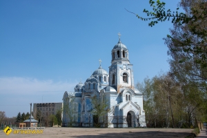


Kirovohrad region is the geographic centre of Ukraine — the very point marked by a sign outside Dobrovеlychkivka. This is where genuine Ukrainian steppe begins: flat as a table, cut by ravines, gullies and granite outcrops along riverbeds. Here stands the only surviving earthen fortress in Europe. Deep inside its forest, haidamaky rebels were gathering even before the Kholodnyi Yar. And here — not in Kyiv, not in Lviv — the Ukrainian professional theatre was born, on a farmstead outside Kropyvnytskyi.
People come here for several reasons. First: the Saint Elisabeth Fortress in Kropyvnytskyi, from which the city itself grew. Second: Khutor Nadiia, the Karpenko-Karyi estate and cradle of the Coryphaeus Theatre. Third: the Black Forest with its Chornolis culture, haidamaky and anti-Bolshevik rebels. Fourth: the Kaskady tract with its rare flatland waterfalls. Fifth: the abandoned coal quarries of the Oleksandriia basin — now landscapes of "Martian" scenery and submerged excavators.
Region at a Glance
| Administrative centre | Kropyvnytskyi (until 2016 — Kirovograd) |
| Area | 24 588 km2 |
| Population | ~900 thousand |
| Historical land | Steppe Ukraine, Inhul river basin, southern Central Dnieper region (historically — Nova Serbia and Zaporozhian Liberties) |
| Main rivers | Inhul, Inhуlets, Syniukha, Tiasmyn, Southern Buh (along the western border) |
| Best time to visit | May–June for steppe and parks; September–October for the Black Forest and Kaskady; Kropyvnytskyi year-round |
In This Article
- What makes this region special and why people come
- Geography, landscapes, climate
- History in brief
- Legends and local lore
- Top attractions in the region
- Day trips and weekend routes
- Must-do experiences
- FAQ
What Makes This Region Special and Why People Come
Kirovohrad region is the most overlooked region of Central Ukraine. It barely appears in classic tourist routes: most travellers drive between Kyiv and Odesa along the M–05 without ever turning off toward the regional centre. That is a mistake. Because here lies a piece of genuine steppe with granite rivers, the only surviving earthen fortress in Europe, a forest where an entire archaeological culture was born, and the theatre from which all of Ukrainian stage life grew.
People come here mainly for three things. First: history that is hard to find elsewhere — Saint Elisabeth Fortress, Nova Serbia, Cossack winter quarters of the Zaporozhian Liberties, the Black Forest of the haidamaky. Second: the abandoned industrial landscapes of the Oleksandriia basin — brown-coal pits where excavators stand submerged in turquoise water. Third: quiet nature — arboretums, the Kaskady waterfalls, granite rapids of the Southern Buh. This is not a place for mass tourism. It is a place for those who want to see the Ukraine that never appears in a top–10 list.
Geography, Landscapes, Climate
Kirovohrad region lies at the boundary between forest-steppe and steppe — the Dnieper Upland, gradually descending southward. The north of the region is dominated by forest-steppe with oak and hornbeam groves (including the legendary Black Forest). The south is typical steppe cut by ravines and narrow ribbons of floodplain forest along the rivers. The Inhul river runs through the entire region, giving the area its historic name — Inhullia.
The region's special feature is its granite outcrops of the Ukrainian Shield. Along the Southern Buh, Syniukha and Tiasmyn, millennia of river erosion have exposed granite, producing rapids, boulders and miniature waterfalls. The most famous of these is Kaskady tract on the Buky river in Malovyskivsky district — a cascading waterfall roughly 7 metres high, rare for the Ukrainian flatlands.
When to visit. The best windows are May–June (steppe in bloom, arboretums at their peak, not yet hot) and September–October (golden Black Forest, soft light, few tourists). July and August are hot and dry — steppe climate, temperatures up to +35 °C, little shade. Winter is best for Kropyvnytskyi's architecture, museums and industrial ruins (there is little snow most of the season).
History in Brief
The lands of modern Kirovohrad region have been settled since at least the Bronze Age. Near the village of Bohdanivka, north of Znamianka, archaeologists in 1949 uncovered a large hillfort that gave its name to the Chornolis (Black Forest) archaeological culture (10th–7th c. BC) — a transitional phase between the Bronze and Iron Ages, one of the best-studied on Ukrainian territory.
In the Middle Ages this was the Wild Field — a no-man's land between the Crimean Khanate and the Polish–Lithuanian state. Cossack routes to Zaporizhzhia crossed the steppe between the Inhul and the Southern Buh. In the 17th–18th centuries, Cossack winter quarters of the Buhorard Palanka of the Zaporozhian Liberties stood here.
In 1752, Russian Empress Elizaveta Petrovna settled this corner with migrants from Serbia, Croatia, Montenegro and Bulgaria, creating the military-administrative unit of Nova Serbia. In 1754, to protect the new settlements from Tatars and Turks, the Saint Elisabeth Fortress was laid — from it grew a city that passed through the names Yelysavethrad, Zinovievsk, Kirovo, Kirovograd and finally Kropyvnytskyi (since 2016).
In the 18th century the region became one of the centres of the haidamaky movement. The Black Forest and Kholodnyi Yar (territorially already Cherkasy region, but historically linked) served as bases for the rebel bands of Zalizniak and Honta. In 1918–1922 anti-Bolshevik insurgents operated in the Black Forest. During the Second World War it was one of the largest centres of partisan activity in the region.
1939: formation of Kirovograd Oblast in its present boundaries. The oblast's name remains Soviet (honouring Serhii Kirov) despite the renaming of the regional centre — a legal technicality requiring a change to the Constitution.
2022+. Kirovohrad region is a rear-area oblast, with no combat operations. It is regularly targeted by missile and drone strikes on infrastructure (particularly Kropyvnytskyi, Znamianka, energy facilities). Tourist sites have not received direct strikes. The region has become home to over 80 000 internally displaced persons and dozens of relocated enterprises.
Kropyvnytskyi is Ukraine's champion of renaming. In 240 years the city changed its official name six times: Yelysavethrad (1784), Zinovievsk (1924 — after Bolshevik Zinoviev, whom Stalin shot twelve years later), Kirovo (1934), Kirovograd (1939), Kropyvnytskyi (2016 — after Marko Kropyvnytskyi, founder of Ukrainian theatre). Almost every name except the last turned out to be an ideological blunder.
Legends and Local Lore
1. Why the Black Forest Is Called Black
There are three versions, and all of them are dark. The first: the black soil — under the oak canopy lies one of the richest chernozem cushions in Central Ukraine. The second: the density of the forest — even at noon under the crowns it is as dark as night. The third, the most grim: because in the 18th century the forest became a black mark for the Polish nobility — haidamaky hid here, and entire detachments sent to "punish" the rebels disappeared without trace. Locals say: whichever version you choose, all three are true.
2. The Only Surviving Earthen Fortress in Europe
The Saint Elisabeth Fortress in Kropyvnytskyi was built by German engineers in 1754 as a hexagon with bastions and a moat, designed by I. Mentzelius. It was never stormed: Tatar and Turkish raiding parties would turn back at the sight of the ramparts. The fortress was in its prime for fewer than 30 years — with the annexation of Crimea to the Russian Empire in 1783 it lost its military purpose and became a place of exile. To this day it is the only earthen fortress in Europe to have survived in its original plan. The hexagonal outline forms the basis of the coat of arms of Kropyvnytskyi.
3. Khutor Nadiia — the Farmstead from Which Ukrainian Theatre Grew
Thirty kilometres from Kropyvnytskyi, on the banks of the Suhokleia, in 1871 Ivan Tobilevych (Karpenko-Karyi) established his estate and named it after his wife — Nadiia Tarkivska. Here he wrote One Hundred Thousand, The Master, Martyn Borulya. His brothers and theatre companions came here — Mykola Sadovskyi, Panas Saksahanskyi, Ivan Karpenko-Karyi, Mariia Zankovetska, Marko Kropyvnytskyi. This is not just a "literary farmstead". It is the only place in the world where five co-founders of a national theatre simultaneously lived, rehearsed and wrote plays under one roof. Locals say that on July evenings in the garden you can still hear the sounds of declamation — not ghosts, but the literature that spread from this farmstead across all of Ukraine.
Top Attractions in the Region
Kropyvnytskyi and the Saint Elisabeth Fortress
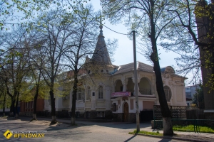
Kropyvnytskyi is the regional centre with the most unusual biography in Ukraine. The Saint Elisabeth Fortress (1754) — the only surviving earthen fortress in Europe, from which the city itself grew — is today a 6-hectare hexagonal complex of ramparts and moats above the Inhul, with a memorial and open walking area. In the city: the Kropyvnytskyi Academic Ukrainian Music and Drama Theatre, Ukraine's oldest (founded 1882); the Inhul embankment; former Yelysavethrad merchant mansions from the late 19th century; the regional history museum with Trypillian and Scythian collections.
Khutor Nadiia — Cradle of Ukrainian Theatre
The Khutor Nadiia museum-reserve in the village of Mykolaivka outside Kropyvnytskyi is Ivan Karpenko-Karyi's estate and the family seat of the Tobilevych clan. The restored playwright's cottage, farm buildings, park, pond. The museum holds over 7 000 exhibits, plus the world's only museum of the history of Ukrainian choreographic art (opened 2004). Every July a theatre festival is held here with open-air performances. An absolute must for anyone who loves Ukrainian literature and theatre.
Black Forest
Black Forest is a massif of oak and hornbeam woodland in the north of the region (Znamianka and Oleksandrivka communities), covering about 65 square kilometres — the southernmost large forest on the forest-steppe/steppe boundary. People come here for three reasons: the Chornolis culture (the hillfort near Bohdanivka where the culture was identified in 1949), the haidamaky history (18th-century rebel bands hid here) and simply for walking — this is a genuinely wild forest, with narrow paths and no mass tourism.
Kaskady Tract
Kaskady tract on the Buky river in Malovyskivsky district is one of the few genuine waterfalls on the Ukrainian flatlands. The river drops over granite boulders in several steps; the total cascade height is about 7 metres. Nearby there are granite rock pools where you can swim. A low-traffic, highly photogenic location — especially in May (high water) and October (golden autumn).
Abandoned Quarries of the Oleksandriia Basin
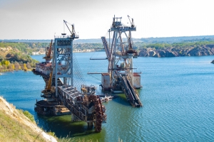
The Oleksandriia brown-coal basin — once one of the largest in Ukraine, now a unique industrial landscape. The best-known sites: Abandoned Kostiantynivskyi quarry with submerged excavators in Berezivka — a multi-level pit with turquoise water and machinery abandoned right in the lake; Abandoned Morozivskyi coal quarry in Pantaivka with views over "Martian" terraces. Nearby: Church of Joseph the Betrothed in Berezivka and the semi-abandoned farm in Bandurivka. This is the best post-industrial tourism route in Central Ukraine.
Veselі Bokovenky Arboretum
Veselі Bokovenky Arboretum named after M. L. Davydov on the Bokovenka river (Dolynska district) is one of the oldest park ensembles in the region, established in 1893 by landowner Mykola Davydov. About 1 000 species of trees and shrubs, three lakes (swimming allowed), its own waterfall, gazebos, children's play areas. Not quite Sofiyivka, but atmospherically coherent and untouristy. An ideal place for a family picnic.
Oleksandriia and the Pearl of the Steppe Park
Oleksandriia is the second-largest city in the region and the historic centre of the brown-coal industry. The must-see here is Pyshchevych House — a vivid example of Yelysavethrad provincial architecture from the 19th century. In the city: Pearl of the Steppe Park (one of the most extensive landscape parks in southern Kirovohrad region) and Shevchenko Park with its cultural and sports complex.
Znamianka — the Railway Gateway of the Region
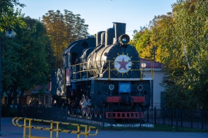
Znamianka is a city that literally grew from the railway — one of the largest rail junctions in Central Ukraine. The main tourist attraction is the Steam Locomotive monument at the station. Nearby is the entrance to the Black Forest; Znamianka is a convenient starting point for routes toward the Chornolis culture and Bohdanivka.
Svitlovodsk and the Kremenchuk Reservoir
Svitlovodsk is a young city (founded 1961 in connection with the construction of Kremenchuk HPP) on the shore of the Kremenchuk Reservoir. Best beaches and water recreation in the region, fishing, boat trips. From here you can see the opposite Cherkasy bank and the HPP dam.
Bobrynets and the Ascension Church
Bobrynets is a small town in the south of the region with a surprisingly rich architectural heritage. The main point of interest is the Church of the Ascension of the Lord (1898) — a stone structure in the Neo-Russian style. Notably, it was in Bobrynets in 1882 that Marko Kropyvnytskyi staged one of the first productions of the Ukrainian professional theatre.
Day Trips and Weekend Routes
Route 1. Theatrical Kropyvnytskyi — One Day
A day in Kropyvnytskyi: morning — the Saint Elisabeth Fortress (1.5 hours walking the ramparts), then the historic centre with its Yelysavethrad merchant houses, lunch in the city. After lunch — drive to Khutor Nadiia in Mykolaivka (~30 km, 40 minutes). If time allows — dinner and a performance at the Kropyvnytskyi Theatre. The region's most compact "cultural" route.
Route 2. Post-Industrial Oleksandriia — One Day
From Kropyvnytskyi or Dnipro to Oleksandriia. Start at the Abandoned Kostiantynivskyi quarry with submerged excavators in Berezivka, then the Morozivskyi coal quarry in Pantaivka with its viewing points. A stop at the Church of Joseph the Betrothed in Berezivka and the semi-abandoned farm in Bandurivka. Lunch in Oleksandriia, stroll through the centre. A route for fans of industrial aesthetics, drone photography and abandoned places.
Route 3. Black Forest and Znamianka — One Day
From Kropyvnytskyi or Cherkasy to Znamianka. See the Steam Locomotive monument at the station, then drive to Black Forest for a walk (choose your trail by the weather; the southern section of the forest is the most wild). A stop in Bohdanivka at the site of the Chornolis hillfort. Return in the evening. A route for lovers of history, forest and quiet.
Route 4. Nature of Kirovohrad Region — Weekend
A two-day route for active recreation. Day 1: Kaskady tract on the Buky river (Malovyskivsky district) — swimming in granite rock pools, picnic. Drive to Veselі Bokovenky Arboretum, overnight nearby. Day 2: walk through the arboretum (lakes, waterfall), return with a stop in Svitlovodsk at the Kremenchuk Reservoir. The best nature route in the region.
Must-Do Experiences in Kirovohrad Region
- Walk the ramparts of Saint Elisabeth Fortress in Kropyvnytskyi — the only earthen fortress in Europe you can walk around on foot.
- Watch a performance at Khutor Nadiia on a July Sunday — Karpenko-Karyi's play under the open sky, on the very grass where it was written.
- Descend to the "Martian" Kostiantynivskyi quarry in Berezivka and look at the submerged excavators in turquoise water.
- Walk the trail through Black Forest to Bohdanivka — the place that gave its name to an entire archaeological culture.
- Swim in the granite rock pools of Kaskady tract — one of the few flatland waterfalls in Ukraine.
- Try telуzhka — the traditional dish of Kirovohrad region: a thick potato bake with meat and sour cream.
- Order kruchenуky in the old Kirovograd style — meat rolls filled with walnut, prune or minced meat.
- Buy honey from the apiaries of Oleksandrivshchyna — acacia and sunflower, meadow-flower, buckwheat.
- Bring back the cookbook "Smachna Kirovohradshchyna" or materials from the "Baba Yelka" project — an ethnographic culinary expedition by local food enthusiasts.
- Stand at the geographic centre of Ukraine near Dobrovеlychkivka — there is a monument and plaque marking the exact spot.
Ukrainian professional theatre did not begin in Kyiv. On 27 October 1882, in Yelysavethrad (now Kropyvnytskyi), Marko Kropyvnytskyi staged Natalka Poltavka with a troupe that included Mykola Sadovskyi, Panas Saksahanskyi, Ivan Karpenko-Karyi and Mariia Zankovetska. That performance is considered the birthday of Ukrainian professional theatre — which is why since 2016 the regional centre bears the name Kropyvnytskyi.
Frequently Asked Questions
What can I see in Kirovohrad region in one day?
The classic option is Kropyvnytskyi with the Saint Elisabeth Fortress and a trip out to Khutor Nadiia (~30 km from the city). The industrial alternative is the Oleksandriia + Kostiantynivskyi quarry + Morozivskyi quarry in Pantaivka route.
Is it safe to visit Kirovohrad region now?
Yes. Kirovohrad region is a rear-area oblast; there are no combat operations here. Missile and drone strikes on energy infrastructure occur periodically (especially around Kropyvnytskyi, Znamianka, Svitlovodsk), but tourist sites have not received direct strikes. Before travelling, do the standard check via official channels and the Povitriana tryvoga app.
Where to go with children in Kirovohrad region?
Veselі Bokovenky Arboretum — a full day with lakes, children's play areas and picnic gazebos. Kaskady tract for active families (swimming, granite boulders, waterfall). Svitlovodsk with its beaches on the Kremenchuk Reservoir. In Kropyvnytskyi — the Inhul embankment and the regional history museum.
What makes Saint Elisabeth Fortress unique?
It is the only surviving earthen fortress in Europe from the 18th century to have reached us in its original plan. A hexagon with six bastions, a moat and three gateways; area 6 hectares. It was never stormed — its very design deterred Tatar and Turkish attacks. The fortress outline forms the basis of Kropyvnytskyi's coat of arms.
Why was Kropyvnytskyi renamed so many times?
Because it has the longest and most ideological biography of any regional centre. Yelysavethrad (1784 — after St Elisabeth and the empress), Zinovievsk (1924 — after the Bolshevik who was shot), Kirovo (1934), Kirovograd (1939 — after Serhii Kirov) and finally Kropyvnytskyi (2016 — after Marko Kropyvnytskyi, founder of Ukrainian theatre). Five renames in 240 years — an absolute Ukrainian record.
What are the most famous dishes of Kirovohrad region?
Telуzhka (a thick bake of potato, meat and sour cream), kruchenуky (meat rolls with various fillings), hocachi (local corn pancakes), frenzolky (a kind of fried flatbread), salnуky, hrechanyky, marinated silver carp from the Kremenchuk Reservoir. Regional varenyky come in dozens of filling variations — from potato with mushrooms to liver with onion.
What to bring back from Kirovohrad region?
The cookbook "Smachna Kirovohradshchyna" or materials from the "Baba Yelka" ethnographic project; honey from the apiaries of Oleksandrivshchyna and Znamianska (acacia, buckwheat, sunflower); cold-pressed sunflower oil; a souvenir miniature of Saint Elisabeth Fortress; a postcard from Khutor Nadiia; dried fish from the Kremenchuk Reservoir.
When is the best time to visit Kirovohrad region?
The best windows are May–June (steppe in bloom, parks at their peak, moderate temperatures) and September–October (golden Black Forest, full water at Kaskady, few tourists). July and August are hot and dry — steppe climate, up to +35 °C. Winter is good for Kropyvnytskyi's architecture, museums and abandoned quarries (little snow most of the season).
Kirovohrad region is the kind of place you have to stumble upon. It is absent from mainstream itineraries; it does not appear in top lists. But that is precisely why it is still real: steppe not fenced off by hotels; a forest where you don't bump into tour groups; a quarry where excavators stand just as they were abandoned in the 1990s; a playwright's estate where on July evenings the silence is so deep you can hear the crickets from two kilometres away.
If you travel the Kyiv–Odesa highway — turn off the M–05 toward Kropyvnytskyi. It will cost you three extra hours. It will give you memories that no amount of Carpathian scenery can match.
JoomShopping Download & Support